


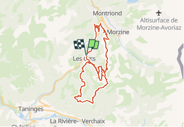
Les Gets

HG74250
User

Length
36 km

Max alt
1660 m

Uphill gradient
1335 m
Km-Effort
53 km

Min alt
1038 m

Downhill gradient
1336 m
Boucle
Yes
Creation date :
2018-06-26 12:37:46.103
Updated on :
2020-01-04 17:50:54.398
3h19
Difficulty : Medium

FREE GPS app for hiking
 SityTrail
IGN / Geographical institutes
SityTrail Plus
The world is yours!
About
Trail Mountain bike of 36 km to be discovered at Auvergne-Rhône-Alpes, Upper Savoy, Les Gets. This trail is proposed by HG74250.
Positioning
Country:
France
Region :
Auvergne-Rhône-Alpes
Department/Province :
Upper Savoy
Municipality :
Les Gets
Location:
Unknown
Start:(Dec)
Start:(UTM)
319819 ; 5114203 (32T) N.
Comments